.png)


Changing Face of the Chesterfield Canal
Type:Walking Event
Chesterfield
Derbyshire
S41 7UB
Call direct on:
Tel01246 345777


About
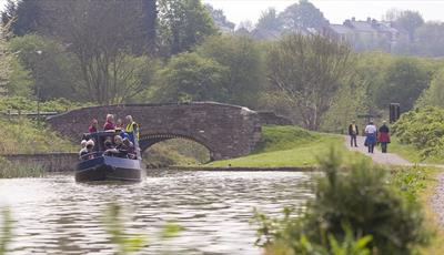
Join one of the Derbyshire Countryside Service team on a walk along the Chesterfield Canal towpath.
There is lots of new development coming up and we’ll chat about the effects and changes this might bring between Chesterfield Waterside and the Staveley Town Basin.
As this is a linear walk, you will return to the train station via public transport once the walk has ended unless you make other arrangements.
Booking essential
Find us on whatthreewords - ///digs.panic.beside
Grid reference – SK 38797 71390
This is a linear walk
No stiles
Bring a packed lunch
Organised by Derbyshire County Council Countryside Service
Guide Prices
Free of charge. Booking essential
Facilities
Property Facilities
- Dogs Accepted - Must be on a lead
- Public toilets - Toilets available at some point on the route
Routes
- Accessibility of route - Leisurely
- Description of route - Linear walk, no stiles, 3-4 rest stops, bring a packed lunch.
- Length of route (miles) - 5 miles
- Typical duration of route - 4 hours
Opening Times
Sorry, this event has passed
Map & Directions
Road Directions
There is private parking at the Railway Station or at Brimington Road and the directions below are to the Station.
From North/South Leave M1 at junction 29 and follow A617 to Chesterfield (approx 4 miles). At traffic light controlled roundabout select middle lane and take 3rd exit. At next roundabout select right lane and take 2nd exit (Lordsmill Street). Keep in right lane and, at traffic lights go straight on. Follow road round Crooked Spire Church and, at traffic lights select right lane and go straight on. At next traffic lights select right lane and follow signs to Sheffield Road and Station round roundabout. Exit down Brewery Street and follow road to roundabout. Go straight on to railway station.
From East Follow A617 to junction with M1 motorway, then follow route from North/South.
From West Follow A619 to Chesterfield. At traffic light controlled roundabout (Matalan) select middle lane and take 2nd exit turning left into Rutland Road. Select right hand lane and, at traffic lights at top of hill turn right. Follow road to roundabout with car park in middle. Select right hand lane and take 3rd exit down Brewery Street (signposted for Station). Follow road to roundabout and go straight on to railway station.
Public Transport Directions
Any bus to Chesterfield town centre